Le Col
Add to my favorites

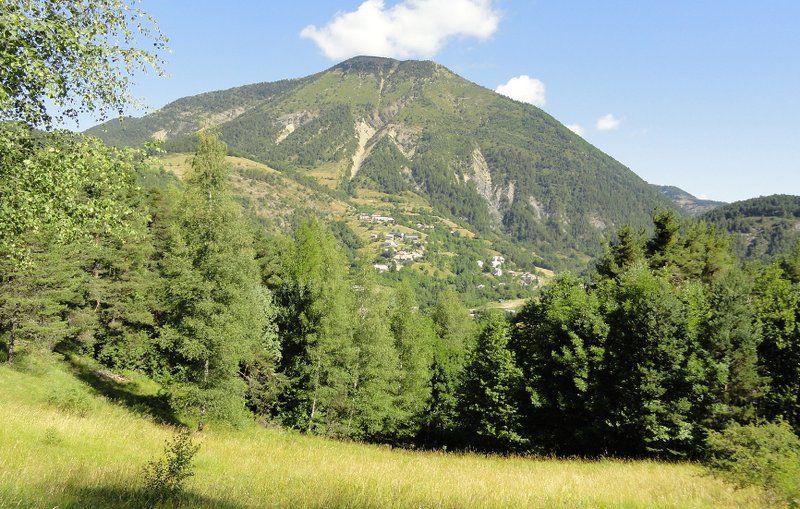
Through this route in a forest atmosphere (resinous trees), you embark for a journey to explore the Auzet countryside with the Clot de Bouc as a background.
The characteristics of the route.

Auzet (04)
- Distance 6.2 km
- Elevation gain 260 m
- Elevation lost 260 m
- Min. elevation 1136 m
- Max. elevation. 1351 m
- Duration (depending on pace) 2h
- Suivre le balisage Yes

Starting from the centre of the village of Auzet, this hike will allow you to discover the hamlet of Auberts and then, after climbing up through the woods, the meadows of the Col. The return route goes through the Sansenu forest.
Starting from the square in Auzet, follow the departmental road downhill and turn left as soon as you can, near the playground. Go over the torrent and turn right. When arriving at the Auberts hamlet, follow the uphill road on the left, pass a hump and emerge at a crossroad.
Les Auberts: Go downhill in the hamlet and go over the torrent. At the next crossroad, turn left on the dirt path and go, once again, over the Grave torrent. Follow it and reach a fork.
L’Acrin: Go up the left path in the Acrin forest and arrive on the high meadows of the Col. Continue on the main path and after gaining some altitude, come across a new crossroad.
Sansenu forest: Go on the right path. Shortly after, arrive at a three-way junction and follow the less pronounced track on the right. This forest path goes down the Sansenu forest to the Grave torrent. Upon sighting it, take the path on the right along the slope of the track, ascend to the edge of the stream, and emerge onto a path. Follow it to the right, pass by the sewage treatment plant, and rejoin L’Acrin. Continue straight ahead and return to the starting point following the same route as before.
Area : Blanche Serre-Ponçon
Report a problem
THIS ROUTE IN YOUR MOBILE PHONE
Download Provence Alpes Outdoor app
Get all the routes on your smartphone with the Provence Alpes outdoor app. You'll find a host of functions :
- Take advantage of detailed IGN maps
- Download data for consultation even when you're not connected to the network
- Geolocate yourself at any time on the route and altimeter profile
- Activate the off-track alarm to be alerted if you stray from the itinerary
- Find nearby services
- Share your experience (add a report, share your lap time)...

Add your time and share your feelings


Information updated on 2025-04-24 by Office de Tourisme Provence Alpes Digne les Bains


Provence Alpes Digne-les-Bains tourist office
+ 33(0)4 92 36 62 62
Tourist office
contact mail
Val de Durance – Château-Arnoux tourist office
+33 (0)4 92 64 02 64
Tourist office
contact mail
![]()
Moustiers-Sainte-Marie Tourist office
+ 33(0)4 92 74 67 84
Tourist office
contact mail
Seyne - Blanche Serre-Ponçon Tourist office
+33 (0)4 92 35 11 00
Tourist office
contact mail
 Provence Alpes Outdoor - Parcours - Le Col
Hello, world! This is a toast message.
Provence Alpes Outdoor - Parcours - Le Col
Hello, world! This is a toast message.
Provence Alpes Outdoor - Parcours - Le Col
Hello, world! This is a toast message.


OK
Annuler