Sommet du Pavillon (1625 m)
Add to my favorites

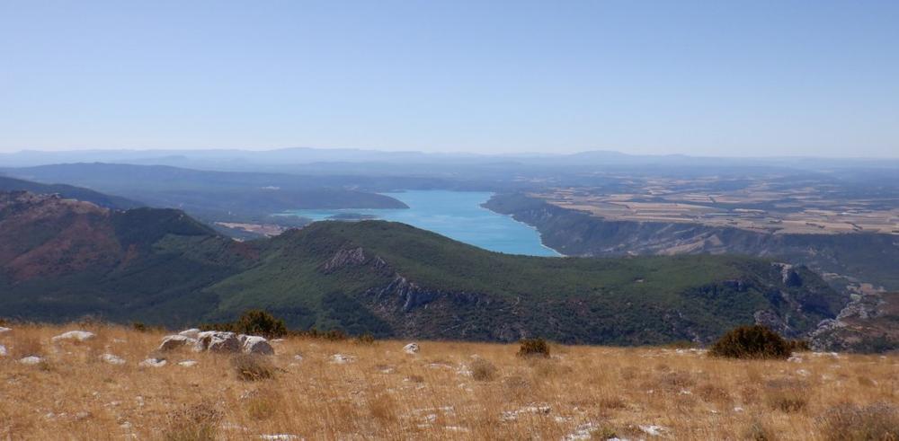
A long hike to discover the summit of Le Pavillon, the highest point on the southern Montdenier ridge, and its marvellous panorama.
The characteristics of the route.

Moustiers-Sainte-Marie (04)
- Distance 23.7 km
- Elevation gain 1140 m
- Elevation lost 1140 m
- Min. elevation 633 m
- Max. elevation. 1620 m
- Duration (depending on pace) 5h
- Suivre le balisage Yes

From Place de l'Église, take Rue de la Clappe. Immediately after crossing the Riou stone bridge, keep to the right and head towards Vincel. At the Montdenier campsite, follow the tarmac road towards the hamlet of Vénascle (approx. 1km).
At the Parking des Plaines, turn left towards Le Pavillon. This will take you uphill for 5km.
At the junction with the wide forest track at Baisse de Montdenier, walk up to Pied du Pavillon. Finish the ascent by reaching the summit of the Pavillon (1625 m altitude) on an increasingly discrete path dotted with small cairns.
On the way back down, return to the forest track and continue straight ahead. You will come to the Montdenier campsite, cross it and follow the same tarmac road as on the outward journey. You will reach the village via Pierrefeu. The descent along the Chemin de Courchon offers a superb panoramic view of the Lac de Sainte-Croix.
The short version of the Pavillon summit : park at the Parking des Plaines (on the Vénascle plateau) and climb to the summit and back. This variant allows you to enjoy the panoramic views and takes around 10km to complete in 4 hours.
23.6 km · 1100m D+ · 7/8h
Area : Verdon
Report a problem
THIS ROUTE IN YOUR MOBILE PHONE
Download Provence Alpes Outdoor app
Get all the routes on your smartphone with the Provence Alpes outdoor app. You'll find a host of functions :
- Take advantage of detailed IGN maps
- Download data for consultation even when you're not connected to the network
- Geolocate yourself at any time on the route and altimeter profile
- Activate the off-track alarm to be alerted if you stray from the itinerary
- Find nearby services
- Share your experience (add a report, share your lap time)...

Add your time and share your feelings


Information updated on 2025-09-17 by Office de tourisme de Moustiers-Sainte-Marie


Provence Alpes Digne-les-Bains tourist office
+ 33(0)4 92 36 62 62
Tourist office
contact mail
Val de Durance – Château-Arnoux tourist office
+33 (0)4 92 64 02 64
Tourist office
contact mail
![]()
Moustiers-Sainte-Marie Tourist office
+ 33(0)4 92 74 67 84
Tourist office
contact mail
Seyne - Blanche Serre-Ponçon Tourist office
+33 (0)4 92 35 11 00
Tourist office
contact mail
 Provence Alpes Outdoor - Parcours - Sommet du Pavillon (1625 m)
Hello, world! This is a toast message.
Provence Alpes Outdoor - Parcours - Sommet du Pavillon (1625 m)
Hello, world! This is a toast message.
Provence Alpes Outdoor - Parcours - Sommet du Pavillon (1625 m)
Hello, world! This is a toast message.


OK
Annuler